Pax Nortona – A Blog by Joel Sax
From the Land of the Lost Blunderbuss
Month: October 2007
Back to Boring
Posted on October 24, 2007 in Santiago Fire
 The smell of burnt chamise, sage, and buckwheat is strong, the smoke thick, but the flames have marched to the east where they have forced the evacuation of our local juvenile delinquents. The fire’s gone into the backcountry — on federal land where it will probably burn through its life until rain or contrary winds extinguish it. The adventure seems to be over.
Most of my immediate neighbors disappeared. They drew out in the first voluntary evacuation leaving a few of us who did not panic at the ashfall and the sight of orange flames in the night. Now it is time to clean up the mess. I have a pair of plastic chairs that the wind blew beneath our deck to fetch and ash to spray off the stairs.
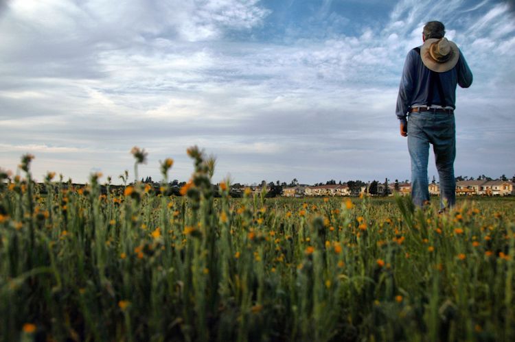
I’ll see what there is to see of the burnt out lands tomorrow or whenever they allow me into Whiting.
There’s an Orange Moon Out Tonight
Posted on October 24, 2007 in Santiago Fire Weather
 I left Portola Hills for the first time since Sunday. I stayed put mostly because we had heard conflicting reports about whether or not they would let us come back. Some said that once you were out, you were out. Others said you could get back in with an ID.
Tonight they merely redirected traffic off El Toro and up Glenn Ranch. They were dismantling the temporary helicopter pad on the Concourse Park lawn — pulling in the hoses, etc. A few people still continued to watch, evidentally in the hope that the whirlybird would take off one last time and disappear into the sunset. By the time we came back, it was gone and the crowd had dissipated.
I only got a passing glimpse at some of the incinerated areas. If I can get into Whiting Ranch, I’ll take some pictures of the devastation. But it won’t surprise me if it is closed.
We went to Rubio’s, a Baja-Californian venue where we had lobster burritos. The air smelled of a thousand barbecues and there was an orange moon out. After we finished dinner, we went to Ralph’s where we picked up a few inessentials. A fellow in line ahead of me was desperate for a cigarette. I wanted to say to him “What do you need that for? All you need to do is go outside and inhale.” But to tell the truth it would not have been nearly as fun because there was no way to blow smoke rings.
This map from Weather Channel has me mystified. It is saying that rain is falling and falling hard. No, I checked the previous doppler scans. You can see the storm forming, just a little bit off the coast of San Diego and in the Santa Monica Mountains. These patches get rapidly large — in the course of an hour until you see the following result. We’re listening hard, wondering where the shower is.
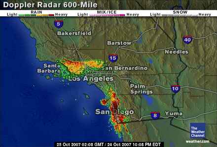
UPDATE: Weather Channel says that we’re in the middle of a downpour but we don’t see it. Wonder what is causing the false positive?
Forest Thinning, not Lumbering
Posted on October 24, 2007 in Conservation Disasters
 There have been a lot of people coming to this blog for no other purpose, it seems, than to blame the Sierra Club for the current wildfires. All of them cite nebulous statistics or just make a “It’s got to be so because I don’t like environmentalists” statement of one kind or another. In the absence of facts, one might want to read what the Sierra Club itself has to say. The article shows that the Sierra Club isn’t against forest thinning but against lumbering that is pretending to be forest-thinning. It also proposes that we simply not build in areas prone to wildfire. There’s a big difference, bubbies.
The legacy of industrial logging has left many unhealthy young stands with far too many trees per acre, and nearly a century of fire suppression has left many forests unnaturally dense and prone to catastrophic fires. How can we get these forests back into a more natural condition?
Unfortunately the laws of economics make it difficult to restore the landscape to a more fire-resistant condition with more large trees. To carry out commercial logging, a landowner is required to prepare a Timber Harvest Plan (THP). If the purpose of the logging, however, is just to thin out smaller trees to create a more fire-safe forest, the cost of preparing the plan would far outstrip the value of the timber revenues. We need a new way to encourage the type of thinning that would enhance the condition of the stand and protect the environment.
Check the article for the method.
Layers and Lines
Posted on October 24, 2007 in Santiago Fire
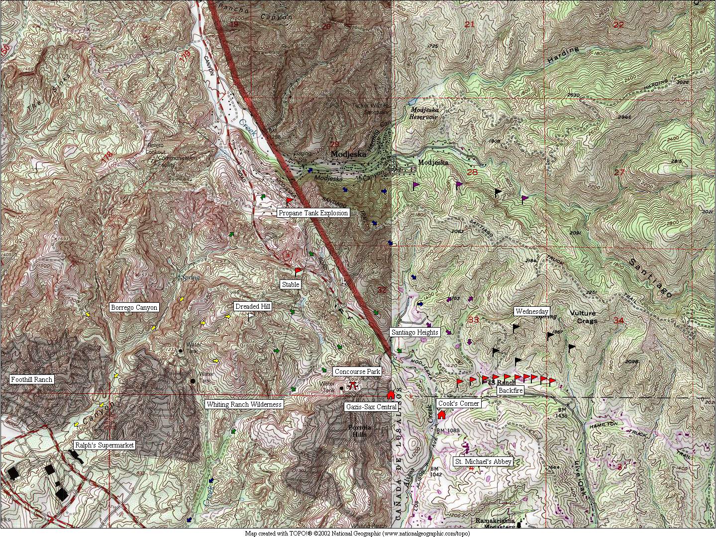
Click on the thumbnail for a topo map diagramming the flow of the fire as I could see it.
Key:
- Yellow: Monday
- Green: Tuesday morning
- Blue: Tuesday Midday
- Purple: Tuesday Evening
- Black: Wednesday
- Red & White: Key Locations
Surrounded by Black, Barren Land
Posted on October 24, 2007 in Photos Santiago Fire

Brian Kane gave me a link and said that I am writing “from the center of the Inferno.” That’s not a bad description. The fire has burned two thirds to three quarters of the way around Portola Hills. Right now, I can see four plumes of smoke: three appear to be in Modjeska/Santiago Canyon and the fourth is clearly burning north of Live Oak Canyon. I might create a topo map later so you can get a rough idea of what has been happening. But for now, more photographs.
The focus of the neighborhood parties has shifted from the overlooks back to Concourse Park where fire crews are servicing a helicopter doing water drops:


UPDATE: An LA Times report on the backfires in Live Oak Canyon.
UPDATE: Feinstein suggests we stop building in fire areas, that we use zoning laws to keep people out. She’s got a point. A large chunk of the homes lost in the San Diego fire were in areas burned out by the 2003 fire. You can talk all you want about planes and fancy stuff, but what are we doing letting people eat up the public dollar by putting themselves at risk, repeatedly?
UPDATE: There’s the strange, beige light all around (see first photograph) that signals smoke in the sky. It’s a good sign because clear skies on the day of a fire mean that the winds are kicking up.
The Heat Goes On
Posted on October 24, 2007 in Photos Santiago Fire

The area which I photographed today. Note the pink streak on the hills near the housing development: this is residue from the flame retardant.

There’s a teensy weensy helicopter flying across the foothills here. Now that the air is still, they’ve been making bucket drops, drawing on local reservoirs. This is a good sign: the winds have died down enough so the choppers can fly. No sign of the C-130s that were here yesterday. Probably are needed elsewhere.

The fire has moved down canyon. The burnt over area to the right is the backfire that they set yesterday afternoon.

Firemen relaxing at Cook’s Corner, the neighborhood’s infamous biker bar. There’s not a lot to do while the fire is burning in the backcountry.
Boring is good, a therapist of mine told me once. And today things are turning boring but hot. The fires plus La Nina have given us a particularly fierce Indian Summer.
I walked to the place where everyone partied yesterday. People came in briefly and left, seeing that nothing much was happening near Santiago Heights save for a single, stubborn fumarole in the ravine behind the development. The fire had denuded the hills and eaten its way east across the hills towards the mouth of Trabuco Canyon and Holy Jim.
Folks took the day off work to watch and unpack their cars. One fellow told me about how a refugee had packed up his car to flee and then been robbed.
No word about who did this, though the news said there was an arrest in San Bernardino County. Radio pointed out that the usual perpetrators of this kind of blaze were people who wanted themselves to be firemen but had been rejected for physical or psychological reasons. So there’s another blow to the terrorism theory.
The one phrase I am not hearing anywhere is “global climate change”. This was made possible by an unusually dry winter. I’d like to see some discussions about how climate is causing this and whether we can expect to see more of this kind of thing.
AHnold is touring the evacuation facility at El Toro High School as I write this.
UPDATE: The LA Times printed this:
Officials were searching for an arsonist responsible for the Santiago fire. In San Bernardino County, a suspected arsonist was shot and killed by police Tuesday night. The shooting was under investigation, but the man was spotted in a brushy area behind Cal State San Bernardino, officials said. After a vehicle pursuit on a dirt road, the man rammed a police car before being fired on by officers, officials said. “There was no reason for him to be back there,” said Lt. Scott Patterson of the San Bernardino Police Department.
Where There’s a Blaze There’s a Bush
Posted on October 24, 2007 in Disasters
Here’s the grim news about how this came to be:
On Tuesday, the Senate’s leading Democrat — Harry Reid of Nevada — said the administration has for years shortchanged funding for prevention efforts to remove the dead trees and shrubbery that provide the fuel for the fast moving blazes….
Reid suggested that the administration failed to heed the lessons of the 2003 wildfires that destroyed some of the same areas of San Diego County that are burning again.
After those fires, Congress authorized up to $760 million a year for “fuel reduction” efforts to clear away dead trees and other combustible material. But only about two-thirds of that — about $500 million — has been provided through the annual budgetary negotiations between the White House and Congress, congressional aides said.
“We have fought for years during this Bush administration to have money for wildfire suppression,” Reid said. “It takes effort to prepare the landscape so that these fires don’t burn the way they have been….That’s what wildfire suppression legislation and [federal] money is all about.”
Sen. Dianne Feinstein, (D-Calif.), who chairs a key funding subcommittee, said, “There is no question that fuel reduction has been under-funded. … In virtually every session, we’ve had to fight for additional money … and I’m prepared to fight again.”
Feinstein also told the Senate that the disaster will be a critical test for FEMA. The biggest challenge could well come after the fires are put out, when the agency will steer residents and business owners to federal programs that can help them rebuild.
While [Jerry] Lewis (R-Calif.) did not criticize the administration, he agreed that the government needs to put a higher priority on prevention. “When we have disasters of this size, the dollars seem to flow on call, but it is more difficult getting continuing dollars to manage the forests long-term,” Lewis said in a floor speech. “We need to continue to address those long-term needs and not allow the current crisis to reduce that effort.”
The federal funds for clearing away dead trees are meant to be spent on federal property, and most of the fires this time are on private and state lands. Nonetheless, Congress may decide in the future to provide some support for state and local efforts.
Ah Fork
Posted on October 24, 2007 in Disasters
You can’t really blame this on anyone:
RAMONA — At 6:30 in the morning Tuesday, Debora Lutz of the U.S. Forest Service got the first sign she was in for a hellacious day in the air war against the Witch.
The Witch fire in northern San Diego County had already devoured more than 150,000 acres, and was eating its way down the San Dieguito River Valley, heading straight for the blue-chip seaside real estate of Del Mar and Rancho Santa Fe.
And now — good morning, Battalion Chief Lutz — the city of Ramona’s main water pump had died, courtesy of a burning power transmission line.
That could mean no water to fill the bellies of Lutz’s small, ad hoc fleet of air tankers based at Ramona Airport. No water to dilute the blood-red fire retardant to the proper color and consistency of strawberry milk.
The four tankers, along with three spotter planes, comprised the entire fixed-wing air force deployed against not only the monstrous Witch fire, but also the Harris fire blazing to the southeast of San Diego, and the Rice fire , about 60 miles north. Lutz had been begging her superiors for more planes, dreaming especially of a DC-10 that could carry about 12,000 gallons of liquid, ten times the load of one of her tankers.
It was in operation elsewhere, she was told.
Off to see what is happening at the party.
Glowing in the Night: The Santiago Fire
Posted on October 23, 2007 in Photos Santiago Fire
If you want to start at the beginning, click here.
The fire is like a necklace stretched across the ebon skin of the hills.

A general view of the fire across the canyon from us, north of Portola Hills. Turned quite pretty hasn’t it?

This is the same area that I showed in the photos that I took earlier today. The fire line is about half a mile away. Firemen are swarming Santiago Canyon Road.

This is an accidentally pretty shot of the backfire that the OCFA set along Live Oak Canyon Road. The red and blue squiggles are the firetrucks lined up along the blaze. For those who don’t understand what is happening here, firemen have taken advantage of negligible winds and set a fire in the path of the larger conflagration. They are watching it closely. The idea is to burn out all the vegetation along the road so that when the main fire reaches this spot there’s nothing for it to feed upon. Around the hill and down the corner from here is a particularly lovely stretch of land where many people have homes. There are also two monasteries and a community church on the hill to the right of this photo. Backfires are a desperation measure: what this signals is that help ain’t coming from anywhere right now. We could, perhaps, have used some soldiers and marines but most of them are over in Iraq doing Bush’s bidding….
We learned that the fire came within three blocks of us while we slept….
[tags]Santiago fire, Santiago Canyon fire, southern california fires, california fires, wildfire, wildfires, disasters, fire department, orange county fire, orange county, southern california, Portola Hills, Trabuco Canyon, fire[/tags]
Beneath the Roar of C-130s
Posted on October 23, 2007 in Photos Santiago Fire

The area around the corner has turned into quite the picnic spot. Someone has even brought out a table and chairs.

An old folk song which reminds me of an Allen Sherman song comes to mind.
I missed the shot of the day when a C-130 flew low over the condominium complex after dropping a load of fire retardant. Wish I’d gotten the photo.
Word is that if you leave Portola Hills they won’t let you back. And, of course, pizza delivery is forbidden.
The Neighborhood Watches
Posted on October 23, 2007 in Santiago Fire
If you want to start at the beginning, click here.

Smoke from one of the arms of the blaze, breaking out along Glenn Ranch Road. Once this has burned through, there’s nowhere for the flames to go except purposefully towards Rick Warren’s Saddleback Church, one of the refugee centers.

The Santiago Heights community is threatened by fire. These flames are moving very slowly because they are going downhill.

A few licks of flame from the previous picture got onto a facing slope. It took the new fire about five minutes to climb from the ravine at the bottom to the tip of the hill. Fire, I was told by one of my neighbors, travels sixteen times faster uphill than down. I can believe it. Good physics: heat rises.
The lack of information leads to speculation. We know that the fire was started by arsonists, but who? “Towelheads,” said one man with a white cairn terrier. “Yeah, must have been towelheads,” said another. “I’d bet it was.” My thinking is that if it was Al Qaeda, they would have claimed responsibility for it by now.
While we were watching from our vantage point in the Canyon Country condominium complex, we saw sheriff’s cars run up every street in the housing development depicted. It was “What the hell are you still doing here?” time. One SUV came out. The firemen were ready to break out the shovels and the hose.
The blaze seems to be headed towards the backcountry where it will putter around for days. It’s probable that once it is finished with Orange County, it will hop the Saddleback and burn on down into Corona, Riverside County.
There’s a ridgeline near here where several people built houses. The road is named the Modjeska Grade. Not so long ago, they were overwhelmed by the fire and you could hear the propane tanks exploding.
Ash Fall
Posted on October 23, 2007 in Photos Santiago Fire
Check the ends of the articles for updates on the situation.

A rain of fine ash such as this is falling as I write this.

The fire burning down Modjeska Grade, towards Santiago Canyon Road, about a quarter of a mile away.

The burned out area near our home. Distance: less than a quarter mile away.

The hero of the hour, one of a team of water bombers which hit the blaze with everything they had.

My neighbors, including Lynn (talking into cel phone to her mother), watching the fire from the top of the hill.
Out of pity, we let the cats out of the carrier. I’m dreading that we’re going to have to put them back in. The winds have died down, but the fire jumped Santiago Canyon Road last night and is now burning out the heart of Modjeska Canyon. Experts are now saying that it will take from five to fifteen days to extinguish.
The jump into Modjeska Canyon means that the fire has all the wild acreage of the Cleveland National Forest to nosh upon. Miles and miles of greasewood that has been shooting out its roots just for this blaze. Greasewood lives to be burned. Once all the surrounding plants have been eradicated, it will send up shoots and take over territory that had belonged to buckwheat or coyote brush or manzanita. The next time a fire comes through, it will burn faster.
The strategy now — what with every single resource in the state going to every fire — is to let this fire burn over the chaparral — give it a good cleaning out — and make a stand at the houses. This is what happened just a couple of hours ago and is still happening. Bombers have been making pass after pass at fires burning right on the edge of new housing complexes. One conflagration came very close — practically across the street.
Recall the photos I put up yesterday, of that fine, scrubby country on the slopes of Dreaded Hill. That’s all cinder-land, toasted, crispy critters. It was near there that the fire zigzagged backwards into Modjeska Canyon where it is now bringing down the dreams of everyone who just had to have a lovely old oak tree shading their house instead of listening to fire men who pontificated on the necessity of having Clearance. A community is going to be dead now, its constituents scattered to the four winds.
The good news about the blackened hills is that once the fire passes over them, they will not be a threat in the future.

Two OC Sheriffs keeping people out of Concourse Park. In the background you can see burnt-over Whiting Ranch Wilderness. Stands of prickly pears are just about the only plants that have not been obliterated by the fire-storm. Last night people were saying what a tragedy it would be in the short run, but, if the rains are good, how beautiful it will be in the spring.
JUST NOW: My periodontist’s office called, wanting to schedule an appointment. “N, you’ve got to call me back. The fire is a quarter of a mile away and we’re getting ready just in case we need to leave.” Click.
UPDATE: How to evacuate (LA Times)
UPDATE: The condominium complex has started running the sprinklers. Every few minutes one set turns on while the previous one turns off. It’s been going like this all day. The gardeners came through and carted off all the leaves, fallen branches, and other debris from the two days of high winds. I marked where the fire extinguishers are just in case the ash ignites a stray pile.